
The 266 kilometre Dunn Track from Cocanarup – just out of Ravensthorpe – to Norseman was the first leg of the 10 day, 3200 kilometre Touch the Desert trip.
-
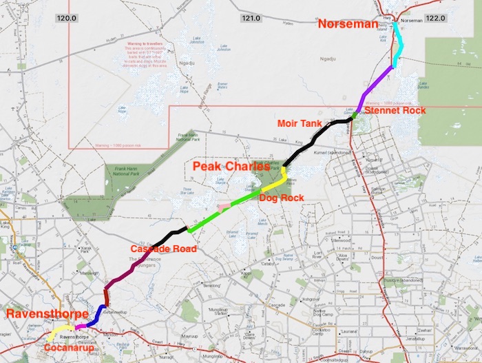
- DUNN TRACK
Wogolin
We met at the site of the long-abandoned hamlet of Wogolin. The crews rolled in, the light faded and the temperature dropped. More wood on the fire. Steve managed to clock up quite a few extra kilometres before he found the camp.
-

- Our camp at Wogolin.
-

- Mushy flying his drone at the Wogolin campsite.
Cocanarup
A seven vehicle convoy left Wogolin in the morning. We met Brad and Jane at Newdegate and made our way through the Great Southern to the start of ‘expedition proper’ at Cocanarup, just short of Ravensthorpe.
We hit the South Coast Highway and six kilometres to the east we turned onto Cocanarup Road, heading to the start of Dunn Track.
-

- DAY 2 ROUTE
-

- At the start of the Dunn Track.
-

- Emu footprint
A small sign pointed to John Dunn’s grave. The story of his death is surrounded by controversy. The narrative suggests that he was ambushed and speared by the local Nyoongars because he raped a young aboriginal girl. The narrative continues that his brothers’ retribution resulted in the deaths of up to forty Nyoongars. The truth of the tragedy will never be known.
-

- John Dunn’s grave.
Phillips River
Leaving the grave, we crossed the Phillips River. Though tame at the time, inspection of the riverbed downriver from the crossing point shows that it can have a massive flow and would indeed be an obstacle to anyone wishing the travel Dunn Track from Cocanarup in the wetter months.
-

- Brad at Phillips River.
-

- Phillips River.
-

- Jane at Phillips River.
-

- Crossing the Phillips River
We continued about five kilometres through bushland. Partway along the stretch of bushland we came across a dam in a clearing. Difficult to understand its purpose.
-

- Earthen contour wall directs water into the dam
Once through a ‘cocky’s gate’ it appeared that we were driving through paddocks instead of a track.
-

- Cocky’s gate along the track with requisite hand painted information sign.
Ravensthorpe
Ravensthorpe was our last chance to refuel before Norseman, 350 kilometres distant, and with 100 kilometres travelled since Newdegate most people elected to top up.
-

- Ravensthorpe
We headed out of Ravensthorpe, turned on to Carlingup Road and had lunch on the Track at a clearing just before the Jerdacuttup River. After lunch we took what was signposted as the Woodinup Track off Carlingup Road as I believe it more closely follows the original Dunn Track. Some doubted that we would be able to get through to Nindilbilup Road to enable us to get to the gate through the vermin proof fence but their fears were unfounded.
Coujinup Track
Through the fence the Dunn Track has been given the moniker of ‘Coujinup Track’.
-

- Alternative name for Dunn Track east of Nindibilup Road and through the vermin proof fence
-

- Mudhole on Dunn Track.
Eleven kilometres further on ‘the Coujinup Track’ diverted to the south-east and we continued on the singularly-titled Dunn Track to the north-east. The country had recently been ravaged by bushfire and was looking decidedly sad.
-

- Mushy and Ray across Cascade Road.
Exciting Boghole
Two kilometres after Peters Soak we came across a boghole.
-

- Santokh powers his Prado through a boghole.
-

- Mushy makes a splash.
-

- Brad and Jane in the Troopy.
-

- Steve’s BT50.
Track to Nowhere
Just after Hewby Swamp Dunn Track crosses a shotline on the way to Northover Soak. Unfortunately the Track disappears around this point and we, like many others before us, had to return to the shotline, drive about two kilometres south-east and then turn left onto another shotline that parallels the original Dunn Track. A few weeks with a chainsaw might change the situation but we didn’t have the time.
We were looking for the track to Welcome Soak, north of our route. A suitable track appeared and we took it. This ‘road to nowhere’ actually took us to a desolate corner of Lake Tay. We speculated on its reason for being as it just stopped at the lake. It wouldn’t have been cheap to make and seemed to serve no purpose. Intriguing. This seven kilometre track had been rarely used (if ever), however, it was a fun drive with over 106 high speed bends.
-

- Part of Lake Tay.
The sun was dipping towards the horizon and it was time to find a campsite. Fourteen kilometres short of the Dog Rock turnoff we found our temporary home for Saturday 8 August 2020!.
-

- Campsite near Dog Rock with Peak Charles and Peal Eleanora in the background.
-

- Sunset at our second camp.
Peak Eleanora
-

- DAY 3 ROUTE
Not long after starting the day’s journey, rain sheeted in on the drive to Peak Eleanora.
While on his 1848 explorations in the area, Surveyor General John S. Roe named Peak Eleanora after the wife of then Governor, Charles Fitzgerald. He also named nearby Peak Charles after the Governor.
-

- Paul and Andrew on the way into Peak Eleanora.
-
- Track into Peak Eleanora.
-

- Peak Eleanora from access track.
-

- Arriving at Peak Eleanora.
-

- Unnamed lake south of Peal Eleanora.
More Exciting Bogholes
We left Peak Eleanora and rejoined the main track.
A kilometre further along we hit a series of bogholes. Just when we thought we were through the worst Brad’s Troopy, Steve’s BT50 and Paul’s Pajero dropped the left wheels into a deep rut and put the vehicles over at an extreme angle – all three were very close to rolling. Although Santohk’s Prado didn’t lurch over as much as the others it was still enough to give him an early morning wake up call.
But the rain abated.
-

- Series of bogholes that stretched for 2600 metres, 17 kilometres after leaving camp and six kilometres before Peak Charles. Three of our vehicles fell sideways into holes, causing them to tip at scary angles.
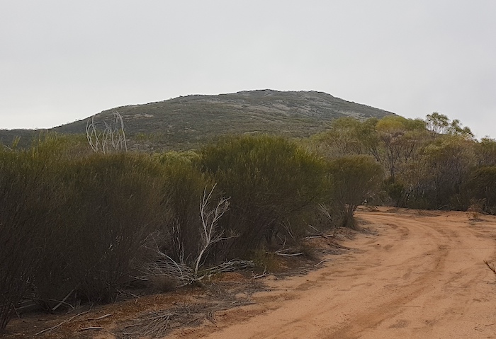
Peak Charles
After that excitement the drive through Annes Pass to Peak Charles was anticlimactic. The wind was still howling when we arrived at Peak Charles and it was as lazy as it gets. Our planned assault on the peak and the lookout at the top (about two hours return) was postponed for a future visit. Mushy put up his drone but was unable to summit.
-

- Mushy’s drone.
The cairn on Peak Charles was constructed by Arthur Hewby and Guy May during their survey of the track in 1910.
-

- Kim trying to stay warm at Peak Charles.
Dunn Track and Peak Charles National Park are towards the southern edge of the Great Western Woodlands, a national treasure and world-wide significant forest.
Moir Rock
We pushed on to Moir Rock. After the disappointment of not being able to climb Peak Charles, a visit to this delightful place was a consolation. Great views, numerous good campsites, an interesting water harvest tank and a track that accessed everything.
-

- Cairn at the top of Moir Rock with Peak Charles in the background.
-

- Water harvesting.
-

- Water harvesting wall.
-

- Harvest wall.
Moir Rock is a hidden gem and would be preferable to camping at the over-used, DPaW campground at Peak Charles. The track from Peak Charles to the Coolgardie-Esperance Highway is maintained in good condition and it was easy run to the bitumen. We stopped at Stennet Rock.
-

- Dry dam at Mount Stennet.
Although long since abandoned and falling into disrepair, the amount of work that went into the construction of the dam emphasises the importance of water supplies in this dry environment – before the precious liquid was piped from the coast. A few kilometres further on, at McPherson Rock, the dam has been maintained. An outbreak of Noogoorah Burr next to the dam was quarantined.
-

- Dam at Mcpherson Rock.
-

- A patch of Noogoorah Burr was quarantined at McPherson Rock.
Dundas
We turned off the Coolgardie-Esperance Highway to the abandoned town of Dundas. Little remains of past glory days. It is an abandoned gold mining town 22 kilometres south of Norseman. Although all buildings have gone, the layout of the streets can be seen and occasional signs provide detail on the town.
-

- Dam at Dundas.
-

- One of the many diggings at Dundas.
-

- Another abandoned shaft
-

- One of the many diggings at Dundas.
-

- An abandoned costean at Dundas.
Norseman
The approach to Norseman signalled the end of Dunn Track.
Over the past months with no community spread of Covid19 the relaxed, even casual approach to the virus in Western Australia was commonplace – but not at Norseman! Situated at the end (or start) of the Eyre Highway the town is acutely aware of its ‘frontline’ status in the battle to keep the virus out of WA.
Norseman provided the opportunity to have a shower and briefly play tourist.
Our Road Trip continued into the Great Victoria Desert.
© Kim Epton 2021-2024
1495 words, 42 photographs, 3 images.
Photographs
Kim Epton
Jane Dooley
James Hay
Michael Orr
Ray Dowinton
Feel free to use any part of this document but please do the right thing and give attribution to adventures.net.au. It will enhance the SEO of your website/blog and Adventures.
See Terms of Use.