Course of the River
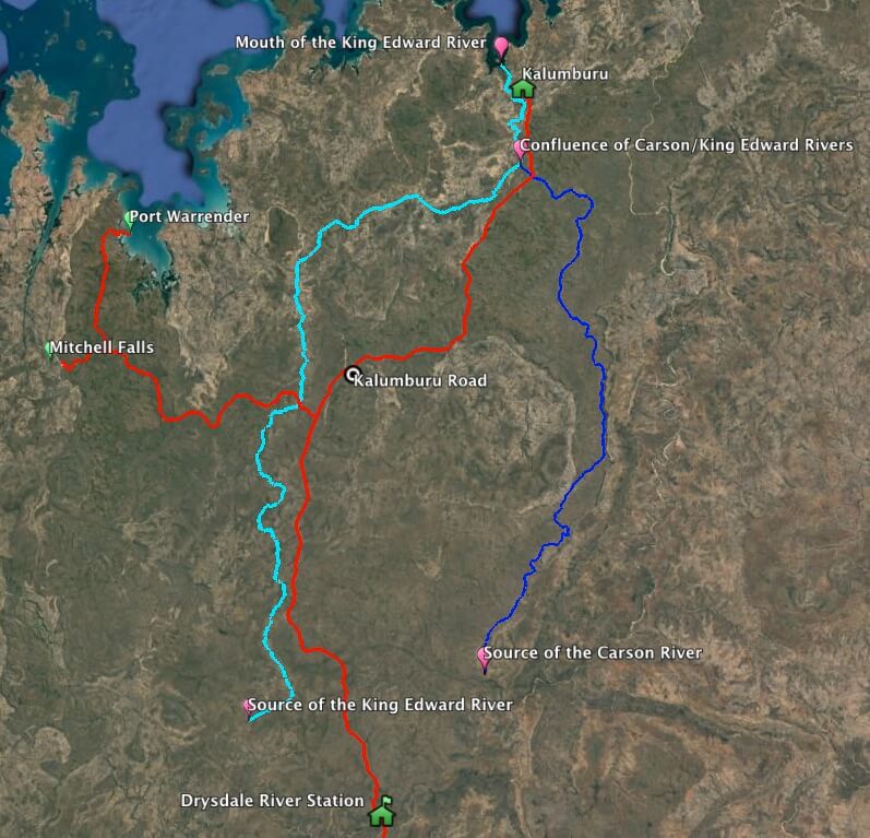
The King Edward River rises 30 kilometres south-west of Doongan Station homestead on the Gardner Plateau. It flows generally northwards to enter the Timor Sea/Indian Ocean at Deep Bay.
Modern day travellers will encounter this river when driving on the Port Warrender Road, six kilometres after turning off the Kalumburu Road. The Campground and Day Use area is a couple of kilometres further on. Travellers have the opportunity to swim at several permanent pools there.
The Kalumburu community relocated to the Kalumburu Pool, 15 kilometres upriver from the mouth of the river, in 1937.
- King Edward River and tributary rivers.
Naming of the River
Government surveyor Fred Brockman discovered the King Edward River in September 1901 during his exploration of the North West Kimberley. He named it after the reigning monarch of the time, Edward VII,
“On the 16th I struck a large river (which I have named the King Edward).”
Edward VII became king of England on 22 January 1901 on the death of Queen Victoria and was crowned on 9 August 1902. He died on 6 May 1910 and was succeeded by King George V.
Brockman discovered the King Edward River at it headwaters. He later picked up its course further down river and traced it to its exit into Deep Bay (part of Napier Broome Bay).
- King Edward River waterfall
Modern day travellers will encounter this river when driving on the Port Warrender Road, six kilometres after turning off the Kalumburu Road. The Campground and Day Use area is a couple of kilometres further on. Travellers have the opportunity to swim at several permanent pools there.
The Kalumburu Community relocated to Kalumburu Pool, 15 kilometres upriver from the mouth of the river, in 1937.
Statistics
LENGTH
221 kilometres
RANKING
7/109
SOURCE
Thirty kilometres south west of Doongan Station Homestead (215 kilometres west of Wyndham)
SOURCE (AMG)
190450 metres East 8283600 metres North
FLOWS INTO
South Napier Broome Bay, Timor Sea
ENDPLACE
Nine kilometres north-west of Kalumburu Mission (210 kilometres north west of Wyndham)
MOUTH (AMG)
240550 metres East 8425900 metres North
TRIBUTARIES
Carson River, eight named creeks and numerous un-named streams
1:100,000 MAPS
Woodhouse 4166, Couchman 4167, Vansittart 4169, King Edward 4168, Carson 4268, Drysdale 4269
1:250,000 MAPS
Ashton SD 52-13, Drysdale SD 52-9
Reference:
Epton, Kim, Rivers of the Kimberley, Hesperian Press, 2000.
Read about other rivers in Western Australia and Australia.
© Kim Epton 2019-2025
400 words, one photograph, one image.
Feel free to use any part of this document but please do the right thing and give attribution to adventures.net.au. It will enhance the SEO of your website/blog and Adventures.
See Terms of Use.


