
The weather was foul. A strong, cold, south-easterly was blowing. The sealed Great Eastern Highway to home was tempting and three crews chose to take it. The remaining four crews chose the originally-planned route along the unmaintained Mt Palmer Track.
The Mt Palmer Track is hardly worth a mention for most of the year but after prolonged rain it was a challenge. It seemed like a never-ending series of long stretches of water, bogholes and slippery, muddy dirt track. And, just as we thought we were through the worst of it – a lake across the Track!
Leaving Great Eastern Highway from the Yellowdine roadhouse there is fair warning that the trip to Mt Palmer may not be all that easy.
-

- Very near the beginning of the Track.
-

- Plenty of warnings.
As matters eventuated it was the most difficult part of the entire Trip. The 12 kilometres to Palmers Find was one stretch of water after another, some up to a hundred metres long, most about 30 or 40 metres.
-

- Big splash.
-

- Steve takes his BT50 through a smaller boghole.
-

- Long and deep.
The depth varied with the deepest being about level with the headlights on the Rodeo. Water in one of the last bogholes caused electrical damage in Steve’s BT50. Later sketchily diagnosed as a faulty alternator, it caused us ongoing issues all the way to Narembeen.
The bogholes ended and we arrived at the historic Mt Palmer fields.
-
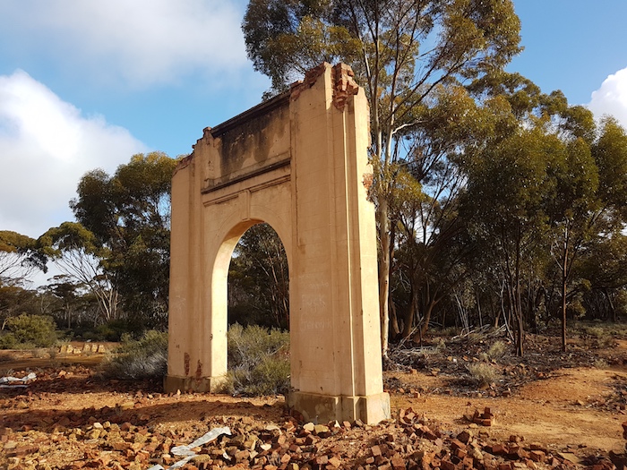
- All that remains of the once grand hotel.
-

- One of the best information boards at an historic site.
The track we wanted was to the west and we figured we were out of the worst of the flooding and bogholes. Not so. As we crested a hill two kilometres west of Mount Palmer we were presented with a challenging sight. An unnamed lake blocked our way. It was about 200 metres across and nearly a kilometre in width. How to approach this obstacle? It was clear that the water level had fallen slightly since the peak of the rainfall event and the littoral of the lake was exposed.
After a number of minutes of consideration I decided that the best course of action was to drive around the edges of the lake rather than drive through it. There was little water present but how boggy was it? Here goes nothing!
-

- Brad sneaks through,
-

- Steve keeping close to the edge.
We snuck around the northern edges of the lake. As we headed back onto the main road we found a hut and a grave.
-

- Memorial to one Kevin John Briggs (1965-1997). A lonely hut is hidden in the scrub 100 metres from the road and 50 metres from the lake was his favourite place according to the incripton on the plaque.
Steve’s vehicle was causing problems. The alternator wasn’t charging and he could drive for only 21 kilometres before the vehicle would stop and need a recharge. We repeated this stop/start procedure for quite a number of hours to get the vehicle into Narembeen. Nobody is left to fend for themselves.
-

- Pumping up Steve’s battery.
-
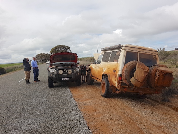
- Oft-repeated procedure.
-

- Brad de-watering connections under the bonnet.
Our route took us 80+ kilometres south on the Emu Fence Road before we turned to the west on Soldiers Road. By this time all fears of bogging on a flooded road had dissipated and it was simply a matter of trying to stay warm while Steve’s vehicle was being charged to be able to drive the next 21 kilometres.
The Road Trip finished at Narembeen. Steve had to wait for a flat top to recover his BT50. Everyone else continued home.
© Kim Epton 2020
641 words, 14 photographs.
Text and Layout
Kim Epton
Photographs
Kim Epton
Jane Dooley
Feel free to use any part of this document but please do the right thing and give attribution to adventures.net.au. It will enhance the SEO of your website/blog and Adventures.
See Terms of Use.